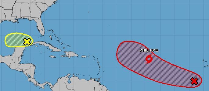
National Hurricane Center forecasters are monitoring a trio of systems including Tropical Storm Philippe, a system off Africa could become a tropical depression by midweek and a low-pressure system that emerged Sunday afternoon in the Gulf of Mexico.
The system off Africa could become a tropical depression in the next few days as it moves west-northwest across the Atlantic, forecasters said. As of 8 a.m. Monday, the National Hurricane Center had given it an 80% chance of developing in the next seven days and a 30% chance in the next two days.
Philippe, meanwhile, was located about 1,265 miles east of the far eastern Caribbean, moving west-northwest at 10 mph with maximum sustained winds of 50 mph, as of 5 a.m. Monday.
Forecasters say the storm is reasonably well organized. The same general motion is expected over the next few days as the storm gradually strengthens, however, its precise path is uncertain. Some models show it strengthening over the next few days, while others show it weakening as a result of shear from a upper-level winds, which generally hinder storm development.
Philippe is currently expected to battle storm-shredding wind shear and then curve northwestward by the middle of the week, away from South Florida.
“While it shows a due-west path, there is expected to be a curve to the north,” said Donal Harrigan, a meteorologist for the National Weather Service Miami. “There’s tons of uncertainty as to how far west or east we’ll go with that curve. I’m not seeing anything that raises a large concern of something reaching South Florida. It looks like this thing is going to stay east of us.”
Tropical-storm-force-winds extended outward up to 115 miles from Phillipe’s center.
Lastly, the storm system that emerged in the Gulf of Mexico Sunday is expected to be relatively short-lived. Further development, if any, is expected to be slow this week as the system moves west. As of 8 a.m. Monday, it was given only a 10% chance of developing as it is expected to be hindered altogether by strong upper-level winds by midweek.
Related Articles
The next named storm would be Rina.
So far this season in the Atlantic, there have been 16 named storms, six of which were hurricanes. Of those, three were major hurricanes, meaning Category 3 or above.
Those were Hurricane Lee, a rare Category 5; Hurricane Franklin, a Category 4; and Hurricane Idalia, which made landfall on Florida’s Big Bend region at Category 3 strength on Aug. 30.
Hurricane season officially runs through Nov. 30.


